T Brook
Share
Copy Link
T Brook
Made by this person or organisation
Refine Results
Name/Title:
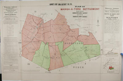
Plan, Rural lands for sale in the Mangatoro Survey District
Maker:
Brook, T, Department of Lands & Survey, Gold-Smith, E C, Smith, Stephenson Percy, Flanagan, F W
Production date:
12 Apr 1900
See full details
Name/Title:
Map, Eketahuna and Mauriceville Counties
Maker:
Smith, Maurice Crompton, Brook, T, Skinner, W A G, Neill, W T, Department of Lands & Survey
Production date:
1922
See full details
Name/Title:
Booklet and map, Mangatahi Settlement
Maker:
Department of Lands & Survey, MacKay, John, Brook, T, Wall, W C, Duncan, George
Production date:
Feb 1907
See full details
Name/Title:
Map, Mangatahi Settlement
Maker:
Williams & Kettle Ltd, MacKay, John, Brook, T, Wall, W C
Production date:
1907
See full details
Name/Title:
Map, Folder of plans and maps of Napier Reclamation Proposals
Maker:
Public Works Architectural Branch, Walshe, Harry Edward, Department of Lands & Survey, Brook, T, Neill, W T, Skinner, W A G, Brett Lithography, Finch, Frank, Herald Lithography, Rochfort, Guy
Production date:
1920-1929
See full details
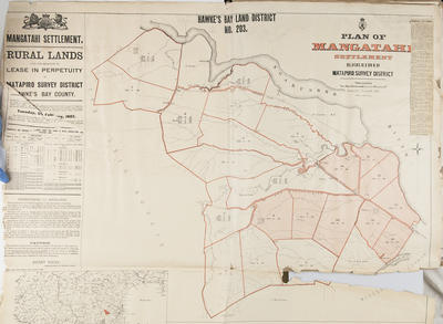 Name/Title:
Plan, Mangatahi Settlement, near Maraekakaho, Hawke's Bay District Number 203
Maker:
Department of Lands & Survey, Murray, W D B, MacKay, John, Duncan, George, Brook, T, Wall, W C
Production date:
1907
See full details
Name/Title:
Plan, Mangatahi Settlement, near Maraekakaho, Hawke's Bay District Number 203
Maker:
Department of Lands & Survey, Murray, W D B, MacKay, John, Duncan, George, Brook, T, Wall, W C
Production date:
1907
See full details
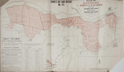 Name/Title:
Plan, Hawke's Bay Land District No 176
Maker:
Department of Lands & Survey, MacKay, John, Duncan, George, Marchant, J W A, Farnie, E H, Brook, T, Department of Lands & Survey, Wilson, James George
Production date:
11 Apr 1905
See full details
Name/Title:
Plan, Hawke's Bay Land District No 176
Maker:
Department of Lands & Survey, MacKay, John, Duncan, George, Marchant, J W A, Farnie, E H, Brook, T, Department of Lands & Survey, Wilson, James George
Production date:
11 Apr 1905
See full details
 Name/Title:
Plan, Hawke's Bay land district No 133 land for sale
Maker:
Goldsmith, E C, MacKay, John, Marchant, J W A, Flanagan, F W, Department of Lands & Survey, Duncan, George, Hay, James, Farnie, E H, Brook, T, McAlister, W C
Production date:
1901
See full details
Name/Title:
Plan, Hawke's Bay land district No 133 land for sale
Maker:
Goldsmith, E C, MacKay, John, Marchant, J W A, Flanagan, F W, Department of Lands & Survey, Duncan, George, Hay, James, Farnie, E H, Brook, T, McAlister, W C
Production date:
1901
See full details