William Nelson
Date Born/Established
02 Aug 1861
Date Died/Ceased
1937
Share
Copy Link
William Nelson
Made by this person or organisation
Refine Results
Name/Title:
Cadastral map, Borough of Dannevirke, 1922
Maker:
Nelson, William Thomas, Skinner, W A G, Department of Lands & Survey
Production date:
1922
See full details
Name/Title:
Plan, Wairoa County
Maker:
Nelson, William Thomas, Marchant, J W A, Department of Lands & Survey
Production date:
Circa 1905
See full details
Name/Title:
Plan, Wairoa County
Maker:
Nelson, William Thomas, Marchant, J W A, Department of Lands & Survey
Production date:
Circa 1905
See full details
Name/Title:
Plan,Napier and Taradale Freehold Properties
Maker:
Williams & Kettle Ltd, Nelson, William Thomas
Production date:
13 Oct 1920
See full details
Name/Title:
Map, Wairoa County, Hawke's Bay
Maker:
Marchant, J W A, Nelson, William Thomas, Department of Lands & Survey
Production date:
1907
See full details
Name/Title:
Plan, Oero District
Maker:
Goldsmith, E C, Department of Lands & Survey, Flanagan, F W, MacKay, John, Nelson, William Thomas
Production date:
Circa 1906
See full details
Name/Title:
Map, Takapau Survey District
Maker:
Flanagan, F W, Goldsmith, E C, Department of Lands & Survey, MacKay, John, Marchant, J W A, Nelson, William Thomas
Production date:
1902
See full details
Objects with this person or organisation as a subject
Refine Results
Name/Title:
Cadastral map, Borough of Dannevirke, 1922
Maker:
Nelson, William Thomas, Skinner, W A G, Department of Lands & Survey
Production date:
1922
See full details
Name/Title:
Plan, Oero District
Maker:
Goldsmith, E C, Department of Lands & Survey, Flanagan, F W, MacKay, John, Nelson, William Thomas
Production date:
Circa 1906
See full details
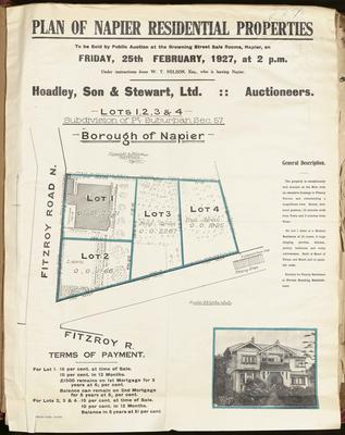 Name/Title:
Plan, Napier residential properties for sale
Maker:
Herald Lithography, Kennedy & Nelson
Production date:
25 Feb 1927
See full details
Name/Title:
Plan, Napier residential properties for sale
Maker:
Herald Lithography, Kennedy & Nelson
Production date:
25 Feb 1927
See full details