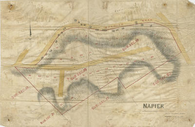
Map, Napier sections
Maker
Lyndon, Edward
Production date
Jan 1875
Current rights
Public Domain
See full details
Object detail
Brief Description
Map of Napier hill sections and subsections bounded by Spencer Road. Some sections have "sold" written in pencil. Shows location of squatters cottages, and an area named Soap Suds Gully.
Scale is one chain to one inch.
Dated January 1875.
Scale is one chain to one inch.
Dated January 1875.
Production date
Jan 1875
Production place
Production period
Media/Materials
Measurements
Folded: Height x Width: 369 x 565mm
Classification terms
Subject period
Subject date
Jan 1875
Current rights
Public Domain
Caption
Collection of Hawke's Bay Museums Trust, Ruawharo Tā-ū-rangi, 2018/4/3
Credit line
gifted by John Mills
Other number(s)
2018/4/3, 95311
Accession number
2018/4/3


Public comments
Be the first to comment on this object record.