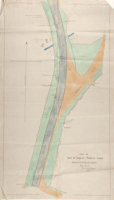
Plan, Part of Napier to Petane Road, Hawke's Bay
Maker
Mace, F E W
Production date
05 Aug 1938
Current rights
Public Domain
See full details
Object detail
Brief Description
The plan depicts part of the Napier to Petane Road with the new bitumen roadway running vertically following the old metal road. The outline of tree plantings have been drawn along the edge of the road and described along with the height of the trees. Wire post fences, telegraph poles and the old bed of the Petane Creek and a drain has been outlined. At each end of the new road the directions to Bay View and to Napier are recorded. The following strange and interesting notations have been written at intervals along the new road:
Puddles car when he first saw Boy.
Bird’s car. Position of Bird’s car when Puddle passed.
Bird’s car. Boy alighted here.
Point Boy was struck Puddles car.
Beside each statement is drawn an oblong shape which signifies a car. This possibly refers to the stages of a car accident or an incident of some description.
Cartographer, F E W Mace.
Date, 5 August 1938.
Maker
Production date
05 Aug 1938
Production place
Production period
Production technique
Media/Materials description
Black ink and watercolours on linen backed surveyor’s paper.
Media/Materials
Measurements
Height x Width: 1100 x 630mm
Classification terms
Subject period
Subject date
Aug 1938
Current rights
Public Domain
Credit line
gifted by David Schultze
Other number(s)
2016/7, 93519
Accession number
2016/7


Public comments
Be the first to comment on this object record.