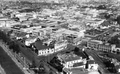
New Napier from the air
Current rights
Public Domain
See full details
Object detail
About this object
An aerial photograph of the New Napier. The city was largely reconstructed after the devastation resulting from the Hawke's Bay earthquake of 3 February 1931. The Central Business District is visible from the air, including Browning, Tennyson, Emerson and Hastings Streets. The top of Marine Parade and the Hawke's Bay Club are visible at the bottom edge of the image.
Photographer, unknown.
Date, unknown.
Photographer, unknown.
Date, unknown.
Production technique
Media/Materials description
Black and white photograph glued into an album of brown paper pages, brown patterned leather covering with gold embossing and tied with cotton.
Media/Materials
Measurements
Height x Width: 86 x 139mm
Classification terms
Subject person
Subject period
Current rights
Caption
Collection of Hawke’s Bay Museums Trust, Ruawharo Tā-ū-rangi, 16675
Other number(s)
16675, Album 34, 83233


Public comments
Be the first to comment on this object record.