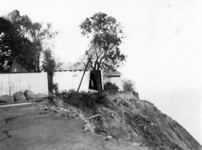
Top of Bluff Hill
Production date
Post 03 Feb 1931
Current rights
Public Domain
See full details
Object detail
About this object
A photograph of the top of Bluff Hill, at the end of Elizabeth Road. Taken after land slips resulting from the Hawke's Bay earthquake of 3 February 1931. The photograph shows the road falling away in the foreground. A garage building is visible right on the edge of the cliff. The photograph was taken 20 March 1931.
Photographer, unknown.
Photographer, unknown.
Production date
Post 03 Feb 1931
Production period
Production technique
Media/Materials description
Black and white photograph.
Media/Materials
Measurements
Height x Width: 82 x 105mm
Classification terms
Subject period
Subject date
20 Mar 1931
Current rights
Credit Line
gifted by Mrs F J Williams
Other number(s)
3980, m69/24, 82878


Public comments
This is the end of Elizabeth Road looking at number 14 'Waimarie'. The street water pipe is still visible today hanging out the cliff edge.
- Rick Hopkinson posted 5 years ago.