Plan, Te Mata land block
Maker
Hawke's Bay Rivers Board
Production date
15 Jul 1907
Current rights
Public Domain
See full details
Object detail
Brief Description
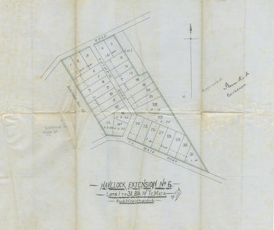
Plan for the Havelock Extension attributed to the Hawke's Bay Rivers Board, dated 15 July 1907.
The plan shows the location and boundaries of lots 1 to 31 of Te Mata Block 4 bordering Guthrie and Te Mata Roads.
The land in question was owned by W Guthrie.
Scale: 3 chains to 1 inch.
The signature is difficult to identify but below it is the title, Governor.
The plan shows the location and boundaries of lots 1 to 31 of Te Mata Block 4 bordering Guthrie and Te Mata Roads.
The land in question was owned by W Guthrie.
Scale: 3 chains to 1 inch.
The signature is difficult to identify but below it is the title, Governor.
Production date
15 Jul 1907
Production period
Production technique
Media/Materials description
Handwritten in black and coloured ink on paper.
Media/Materials
Measurements
Height x Width: 460 x 490mm
Signature/Inscription
W Guthrie, Signature, Handwritten
Classification terms
Subject person
Subject period
Subject date
13 Nov 1908
Current rights
Public Domain
Credit line
gifted by Cotterill and Humphries
Other number(s)
m2010/94/1, 80625


Public comments
Be the first to comment on this object record.