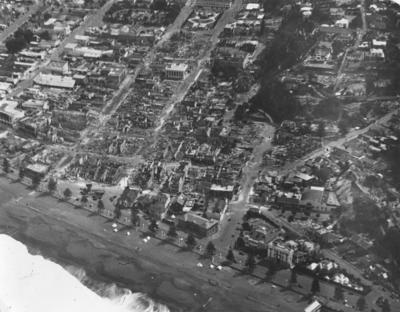
Aerial view of Napier
Production date
Post 03 Feb 1931
Current rights
Public Domain
See full details
Object detail
About this object
Aerial view of Napier taken in February 1931 following the Hawke's Bay earthquake and subsequent fires.
The photograph has been taken from an aircraft, looking west. Marine Parade is located near the bottom of the image. Among the buildings that are visible along the street are the Napier Courthouse, the Hawke's Bay Club, and Dr Walter William Moore's Upoko Poito Private Hospital.
The Central Business District is also visible. Among the streets that can be seen in the photograph are Hastings Street, Dickens Street, Emerson Street, Tennyson Street, Browning Street, Byron Street, and the foot of Shakespeare Road. There is extensive damage to the buildings in this area. One of the few structures that remain standing is the Public Trust Building on Tennyson Street. Clive Square is located at the top of the image.
Photographer, unknown.
Production date
Post 03 Feb 1931
Production technique
Media/Materials description
Black and white photograph.
Media/Materials
Measurements
Height x Width: 168 x 217mm
Signature/Inscription
Copyright. Photograph by "The Evening Post" Wellington - N.Z., Stamp, Stamped
Classification terms
Subject period
Subject date
Post 03 Feb 1931
Current rights
Caption
Collection of Hawke's Bay Museums Trust, Ruawharo Tā-ū-rangi, 15825
Credit Line
gifted by Barry Hellberg
Other number(s)
2012/46/36, 15825, 80320
Accession number
2012/46/36


Public comments
Be the first to comment on this object record.