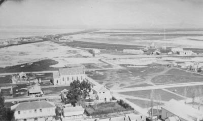
View of Napier
Maker
Williams, F W
Current rights
Public Domain
See full details
Object detail
About this object
View of Napier from Napier Hill looking toward Awatoto, thought to have been taken in 1876 or 1877. Tennyson Street is located at the base of Napier Hill. Clive Square is visible in the right foreground. To the left of Clive Square is the Trinity Methodist Church, which was built in 1876.
Emerson Street and Dickens Street are also visible.
The railway station and the Hawke's Bay Brewery building are visible along the edge of the Inner Harbour on the right side of the photograph.
Photographer, possibly F W Williams.
Emerson Street and Dickens Street are also visible.
The railway station and the Hawke's Bay Brewery building are visible along the edge of the Inner Harbour on the right side of the photograph.
Photographer, possibly F W Williams.
Maker
Production technique
Media/Materials description
Black and white photograph mounted in an album.
Media/Materials
Measurements
Album (closed): Height x Width x Depth/Length: 287 x 240 x 42mm
Photograph: Height x Width: 86 x 145mm
Photograph: Height x Width: 86 x 145mm
Classification terms
Subject person
Subject period
Subject date
1876-1877?
Current rights
Other number(s)
Album 2, 296, 78060


Public comments
Be the first to comment on this object record.