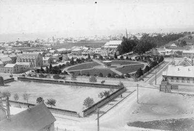
Clive Square, Napier
Current rights
Public Domain
See full details
Object detail
About this object
View of Clive Square from Napier Hill thought to have been taken around 1896. Clive Square is visible in the foreground. The north end of Clive Square is enclosed by a timber fence. The perimeter has been planted with trees. On the opposite side of Emerson Street, the south end of Clive Square features a band rotunda surrounded by a circle of seating. Trees and shrubs have been planted around the perimeter of the park. The park is surrounded by a timber fence.
To the left of Clive Square is Clive Square East. Among the buildings that are visible along Clive Square East are Coachs Carriage Works, the Provincial Hotel (established 1876), the Trinity Methodist Church (built 1876), and W Amner Coal and Fire Wood Depot. Behind Clive Square is the intersection of Dickens Street and Munroe Street. Among the buildings visible along Dickens Street are the premises of Fortune and Black (bakers and confectioners) and the Forester’s Hall. Munroe Street is lined with trees. St Patrick’s Church (built 1894) is located on the left side of Munroe Street. To the right of Clive Square is Main School.
Cape Kidnappers is visible in the distance.
Photographer, unknown.
Production technique
Media/Materials description
Black and white photograph mounted on card.
Media/Materials
Measurements
Photograph: Height x Width: 97 x 140mm
Card backing: Height x Width: 107 x 163mm
Card backing: Height x Width: 107 x 163mm
Signature/Inscription
1896, Inscription, Handwritten
Box 8, Inscription, Handwritten
Mrs F Crabbe Shakespeare Rd Napier, Inscription, Handwritten
H.B. Art Gallery and Museum, Stamp, Stamped
Box 8, Inscription, Handwritten
Mrs F Crabbe Shakespeare Rd Napier, Inscription, Handwritten
H.B. Art Gallery and Museum, Stamp, Stamped
Classification terms
Subject person
Subject period
Subject date
1896?
Current rights
Caption
Collection of Hawke's Bay Museums Trust, Ruawharo Tā-ū-rangi, 4568
Credit Line
gifted by Mr J McGlashan
Other number(s)
m72/16, 4568, 76553


Public comments
Be the first to comment on this object record.