Plan, Hawke's Bay land district No 434 land for sale
Maker
Skinner, W A G
New Zealand Government
Department of Lands & Survey
Production date
24 Feb 1930
Current rights
Public Domain
See full details
Object detail
Brief Description
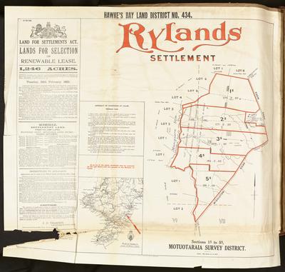
Plan of Hawke's Bay land district No 434 land for sale. Rylands settlement.
Waipukurau County, Motuotaraia survey district.
Twelve chains to the inch.
Reference No: 2291- L-14-115-31.
The property was formerly owned by John MacLennan.
To be open for selection on renewable lease under the Lands for Settlement Act. The land consists of 1,246 acres and will be open for selection to applicants from Tuesday February 24, 1930. Applicants must appear in person, but may be examined by other land boards or Commissioners of Crown Land. Priority will be given to landless applicants and servicemen who have since returned from the Great War.
A Schedule of land is included. The area for lease is of first class land around Middleton Road, Farm Road and bordering the Mangaora Stream. The land consists of area ranging from 196 acres to 299 acres in size.
M Tansey, C E Twist, T E Welch, W Stoddart are adjacent land owners bordering land blocks and the Mangaora Stream to the West. A L Ballard & J W McNutt are neighbours at the North end of the blocks for lease.
Instructions to applicants have been included, from J D Thompson - Commissioner of Crown Lands, District Lands & Survey office - May 1930.
Production date
24 Feb 1930
Production place
Production period
Production technique
Media/Materials description
Plan, printed on paper with black and coloured ink.
Media/Materials
Measurements
Height x Width: 690 x 760mm
Classification terms
Subject person
Subject period
Subject date
24 Feb 1930
Current rights
Public Domain
Credit line
gifted by the Hawke's Bay Farmers'
Co-Operative Association
Co-Operative Association
Other number(s)
m74/37/2/265, 76471


Public comments
Be the first to comment on this object record.