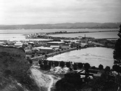
Port Ahuriri and Westshore
Maker
Stedman, Nelson
Current rights
Public Domain
See full details
Object detail
About this object
A photograph of Port Ahuriri and Westshore taken from Bluff Hill looking toward the Ruahine Ranges. The road to the left of the pond is Coronation Street. Coronation Hall is visible. Early houses are visible along Battery Road at the foot of the hill. Across the inner harbour entrance is Western Spit, present day Westshore. There is evidence of settlement and industry.
Photographed by Nelson Stedman.
Date unknown.
Photographed by Nelson Stedman.
Date unknown.
Maker
Production technique
Media/Materials description
Black and white photograph.
Media/Materials
Measurements
Height x Width: 160 x 212mm
Signature/Inscription
Nelson Stedman 226 Remuera Road, Inscription, Handwritten
Classification terms
Subject period
Current rights
Caption
Collection of Hawke’s Bay Museums Trust, Ruawharo Tā-ū-rangi, 6748
Other number(s)
6748, m83/6, 76261


Public comments
Be the first to comment on this object record.