
Plan, Hawke's Bay land district No 241 land for sale
Maker
Department of Lands & Survey
MacKay, John
Production date
10 Jun 1909
Current rights
Public Domain
See full details
Object detail
Brief Description
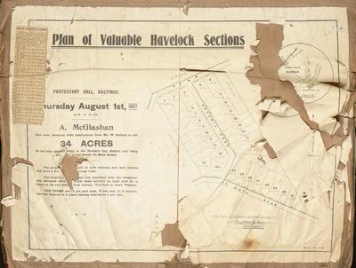
Plan of Hawke's Bay land district No 241 land for sale.
Government printing reference: 800-4/09-319.
Rural lands for selection on the Optional System, consisting of 2,327 acres.
The lands are open for selection under the provisions of the lands for settlements consolidation act, 1900. Applications are to close Thursday June 10, 1909. Included are instructions to applicants regarding previous ownership of lands. Signed Henry Trent, Commissioner of Crown Lands, at the District Lands office, Napier. An abstract of conditions is included noting that the applicants must be 17 years of age and older and, that no person may hold more than 5,000 acres. The terms of lease is 65 years and leaser's have no rights to minerals unless a licence is obtained.
The plan shows land lots, area sizes, boundaries in the Nuhaka survey district around the Nuhaka River, Nuhaka Road - being 3 miles from Nuhaka. The Woodville survey district land is around Harding's Road, consisting of 78 acres.
Production date
10 Jun 1909
Production place
Production period
Production technique
Media/Materials description
Printed on paper.
Media/Materials
Measurements
Height x Width: 560 x 670mm
Classification terms
Subject person
Subject period
Subject date
10 Jun 1909
Current rights
Public Domain
Credit line
gifted by the Hawke's Bay Farmers'
Co-Operative Association
Co-Operative Association
Other number(s)
m74/37/2/44, 75117
Public comments
Be the first to comment on this object record.