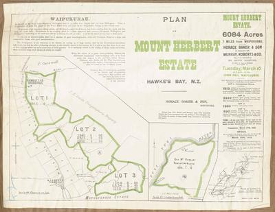
Plan, Mount Herbert Estate land for sale
Maker
Herald Lithography
Baker, Horace
Production date
06 Mar 1909
Current rights
Public Domain
See full details
Object detail
Brief Description
Plan of Mount Herbert Estate land for sale.
Consisting 6,084 acres.
The land lots are to be sold at public auction on Tuesday March 6, 1909. Horace Baker & son with Murray Roberts & Co - auctioneers have been instructed by Henry Gaisford to sell. The land consists of 4 lots from 590 acres to 2,332 acres in size.
The land is situated 44 miles from Napier and 167 miles from Wellington, with a population of 800 in the town board area. The Motuotaraia Estate borders lot 3, close to Wanstead. J E Reid's Tangitupuru property borders lots 1 and 2. J Carswell has land to the North bordering the public road and lot 1 with the homestead buildings.
J C Main has property bordering the old homestead block, close to the Tukituki River. A locality map is included showing the general area to be between Waipawa and Wallingford.
Production date
06 Mar 1909
Production place
Production period
Production technique
Media/Materials description
Printed on paper with black ink.
Media/Materials
Measurements
Height x Width: 445 x 570mm
Classification terms
Subject person
Subject period
Subject date
06 Mar 1909
Current rights
Public Domain
Credit line
gifted by the Hawke's Bay Farmers'
Co-Operative Association
Co-Operative Association
Other number(s)
m74/37/2/42, 75088


Public comments
Be the first to comment on this object record.