Plan, Hawke's Bay Land District No 63
Maker
Department of Lands & Survey
Smith, Stephenson Percy
Hay, James
Roddick, J
Production date
Mar 1896
Current rights
Public Domain
See full details
Object detail
Brief Description
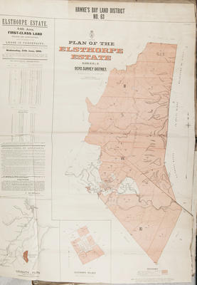
Plan of Hawke's Bay Land District No 63.
Elsthorpe Estate.
Blocks III, VII & XI Oero survey district, Hawke's Bay.
Lands & Survey Reference: S.G 18883.
The land consists first class agricultural & Village land, to be leased in perpetuity. Applications are to open on Wednesday 24 June, 1896. Included is a list of instructions to applicants, noting the office locations with which to make applications and the terms and conditions of buying or leasing the land. Signed by T Humphries, Commissioner of Crown Lands.
Land lots and area sizes, rivers, survey district boundaries are shown around Kairakau Road, Elsthorpe Village, located at the South end of the property, Hawea Road up to the bordering Waimarama No 3 block at the North end. W A Couper has bordering land at the north, R Curling has land to the North West portion of the property, F J Tiffen is a land owner at the Western side of the land blocks, which is also around the Elsthorpe village area.
J N William has land bordering the Southern and South Eastern portion, near Kairakau Road. Rangitira Mata is noted, but not part of the Estate, bordering the Makara Stream. A locality plan is included showing the area to be approximately 10 miles South West of Bare Island.
Maker
Production date
Mar 1896
Production place
Production period
Production technique
Media/Materials description
Printed on paper. Ink.
Media/Materials
Measurements
Height x Width: 950 x 700mm
Classification terms
Subject person
Subject period
Subject date
24 Jun 1896
Current rights
Public Domain
Credit line
gifted by the Hawke's Bay Farmers'
Co-Operative Association
Co-Operative Association
Other number(s)
m74/37/1/271, 74917


Public comments
Be the first to comment on this object record.