Plan, Hawke's Bay Land District No 153
Maker
Flanagan, F W
Department of Lands & Survey
Goldsmith, E C
MacKay, John
Hay, James
Duncan, George
Marchant, J W A
Kennedy, Arthur Angus
Robertson, John A
Production date
23 Jun 1903
Current rights
Public Domain
See full details
Object detail
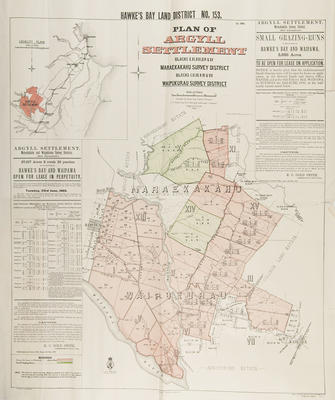
Argyll Settlement.
Lands & Survey Ref: 625-03-481.
Blocks X, XI, XIII, XIV & XV - Maraekakahu survey district.
Blocks I, II, III, V, VI & VII - Waipukurau survey district.
Land available for lease in perpetuity, consisting 27,917 acres in the counties of Hawke's Bay and Waipawa and 5,685 acres of grazing runs in the above area will be open for application on Tuesday, June 23, 1903. Included is a list of instructions to applicants, noting the office locations with which to make applications and the terms and conditions of buying or leasing the land. Signed by E C Goldsmith, Commissioner of Crown Lands.
Land lots and area sizes, rivers, survey district boundaries are shown around Hampden, Mangaonuku River, Waipawa River and Kaikora areas. The Gwavas Estate, Maraekakahu Estate and Taheke Estates border land lots to the North. Abbotsford Estate is to the South, by the Waipawa River and College Land Estate is to the South West, bordering the Pukehou railway station.
Co-Operative Association


Public comments
Be the first to comment on this object record.