Plan, Forest Gate settlement land for sale
Maker
Flanagan, F W
Department of Lands & Survey
Goldsmith, E C
MacKay, John
Hay, James
Duncan, George
Production date
1902
Current rights
Public Domain
See full details
Object detail
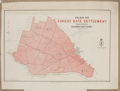
Blocks VII, VIII, XI and XII in the Ruataniwha survey district.
Includes one plan of the area and a locality map.
a) Land lots, area sizes, survey district boundaries, rivers and roads are shown around the Tukituki River, Blackburn Road, Valley Road and Onga Onga. The Fairfield Estate adjoins land lots to the East, near Onga Onga.
Lands and Survey Reference: 1550-4-02-183.
b) A locality map of the above area shows the general location to be West of Fairfield and bordering Onga Onga, West of Waipawa.
Lands and Survey Reference: 1500-3-02-183.
Height x Width: 230 x 205mm
Co-Operative Association


Public comments
This map, and the related locality map, were part of a Lands and Survey land sale 19 May 1902 pamphlet. ArchivesNZ Ref. R675632 pamphlet; and Sale Plan No. 172.
- C Adams posted 2 years ago.