Plan, Hawke's Bay land district No 140 land for sale
Maker
Goldsmith, E C
MacKay, John
Marchant, J W A
Flanagan, F W
Department of Lands & Survey
Production date
24 Jun 1902
Current rights
Public Domain
See full details
Object detail
L & S Ref: 325.6.02.334.
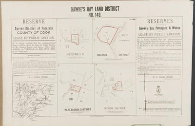
Rural lands open for selection in the survey district of Patutahi, County of Cook, Hawke's Bay, Patangata and Wairoa counties.
The crown lands will be open for sale or selection in terms of section 136 of the Land Act - 1902, either for cash or occupation with rights to purchase of lease in perpetuity, on and after Tuesday June 24, 1902.
a) Patutahi survey district, near the Waikoko stream, consisting 200 acres.
b) Heretaunga district, around the Tutaekuri - Waimata Stream, consisting 8 acres.
c) Mattanga district, at Mahia township, consisting 33 acres.
d) Weber district, near the Akitio River, consisting 12 acres.
A locality map is included showing the Weber, Gisborne, Napier and Mahia areas where the land lots are located.
Co-Operative Association


Public comments
Be the first to comment on this object record.