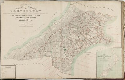
Map, Provincial District of Canterbury
Maker
Whitcombe and Tombs Ltd
von Haast, Johann Franz Julius
Schmidt, H R
Production date
1887
Current rights
Public Domain
See full details
Object detail
Brief Description
Map of the Provincial District of Canterbury which was compiled from the latest Government surveys and completed from Sir Julius Von Haast's original sketch surveys of the Southern Alps, by H R Schmidt.
Shows Provincial District boundaries, County boundaries, Survey District boundaries, townships, tracks and altitudes in feet around Christchurch, Hirunui River to the North, Greymouth, Awarua or Big Bay on the West coast and the Waitaki River on the East Coast.
The proposed route from Greymouth to the East Coast can be seen starting from Greymouth, on to Lake Brunner, running parallel to the Otira River and nearing Lake Merrymore then following the Waimakariri River on to Christchurch.
Production date
1887
Production place
Production period
Production technique
Media/Materials description
Printed on paper with ink.
Media/Materials
Measurements
Height x Width: 595 x 910mm
Classification terms
Subject person
Subject period
Subject date
1887
Current rights
Public Domain
Credit line
gifted by the Hawke's Bay Farmers'
Co-Operative Association
Co-Operative Association
Other number(s)
m74/37/1/141, 74483


Public comments
Be the first to comment on this object record.