Map, Napier Harbour
Maker
Kenny, John Patrick
Production date
Circa 1902
Object detail
Brief Description
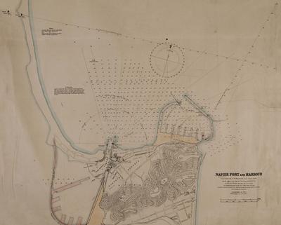
Nautical map of Napier Harbour, Circa 1902.
Napier port and harbour nautical map showing Scinde Island, Ahuriri Lagoon, Westshore Spit and the Glasgow wharf at the Breakwater harbour. The harbour board office is shown at the corner of Shakespeare and Battery Road and the Ferry Hotel is located across the Ahuriri bridge in Westshore. The freezing works are situated next to the entrance to the inner harbour.
Depth soundings are shown in fathoms around the inner harbour and out in the Ahuriri Roadstead. The signal station at Ahuriri Bluff - 330 feet above seal level is visible as is the signal station near Coote Road.
Ahuriri Roadstead mooring buoy is noted at the north end of the outer harbour, near Bay View.
The distance to Pania buoy at Nº16E is noted as 2 1/4 miles.
The barracks can be seen near Spencer Road on the hill by the hospital.
There is a signal station - pilots at the entrance to the inner harbour and the spit railway station is located near Railway Quay in Ahuriri.
Auckland Rock is visible just inside the proposed line of the breakwater and the Bluff light is situated at Lat º39 29' 7" S Long º 176 55' 17"E.
Production date
Circa 1902
Production place
Production period
Production technique
Media/Materials description
Printed on paper.
Media/Materials
Measurements
Height x Width: 540 x 700mm
Classification terms
Subject person
Subject period
Subject date
Circa 1902
Credit line
gifted by Mrs Stewart
Other number(s)
m74/15(b), 73636
Public comments
Be the first to comment on this object record.