Plan, Napier Country Districts, Hawke's Bay
Maker
Buchanan, John Duncan Henry
Production date
1947
Object detail
Brief Description
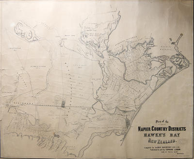
Plan, Napier Country Districts, Hawke's Bay.
Hand drawn copy of plan showing the area from Tuki Tuki River to the south, Pukahu, Heretaunga block, Ohika Karewa, Puketapu district, Scinde Island, Ahuriri harbour and the Western Spit to the north.
Block 9 - Te Mata District - J Chambers is at grid co-ordinate 32, 18.
J D Ormond's property - 1,231 acres is located at grid 24,25.
The Omarunui block - is at grid 20, 32.
The racecourse is noted near Waitangi Creek.
At the lower left of the map is noted:
1) Original is undated however internal evidence ie: Taradale - Napier Road, railway etc suggests circa 1876.
Also noted at right:
2) Tracing from map in Hawke's Bay Museum - cat No5001, traced by J H D Buchanan, January 1947.
Original plan compiled by James Rochfort Esq C E.
Published and sold by Edward Lyndon, Land agent.
Hamel & Ferguson - Lithographer - 85 Queens Street, Melbourne.
Production date
1947
Production place
Production period
Production technique
Media/Materials description
Drawn on paper.
Media/Materials
Measurements
Height x Width: 705 x 855mm
Classification terms
Subject person
Subject period
Subject date
Circa 1875
Credit line
gifted by Mr S Grant
Other number(s)
7095, 72661
Public comments
Be the first to comment on this object record.