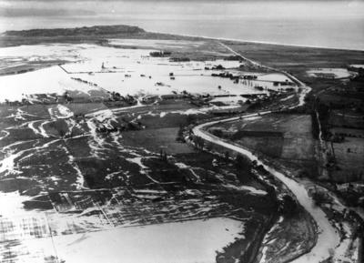
Tutaekuri River flood of 1933, Napier
Production date
29 May 1933
Current rights
Public Domain
See full details
Object detail
About this object
Tutaekuri River flood of 28 May 1933, Napier. Aerial photograph showing the effects of the 1933 flood. Shown are the Meanee [Meeanee] Bridge, Meanee [Meeanee] Breach - North Bank , Richmond Block, New Bank at Breach of April 30th, 1932, Lower Papakura Breach, Upper Papakura Breach, Water from Breach in North Bank opposite Powdrell's Breach.
The photograph was taken on 29 May 1933. Information regarding areas identified in the photograph are written on the back on the card mount.
The photograph was taken on 29 May 1933. Information regarding areas identified in the photograph are written on the back on the card mount.
Production date
29 May 1933
Production period
Production technique
Media/Materials description
Photograph mounted on card.
Media/Materials
Measurements
Height x Width: 275 x 355mm
Height x Width: 250 x 300mm
Height x Width: 250 x 300mm
Signature/Inscription
D.O. RECORD COPY / P.W. 278 NAPIER, Stamp
Classification terms
Subject period
Subject date
28 May 1933
30 Apr 1932
30 Apr 1932
Current rights
Other number(s)
15,556, P W 278, 71805


Public comments
Be the first to comment on this object record.