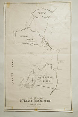
Map, photocopy, McLean's purchases
Current rights
Public Domain
See full details
Object detail
Brief Description
Photocopy of Map Showing McLean's purchases, 1851, from old records.
Shows three main land blocks:
Waipukurau block - 279,000 acres.
Ahuriri block - 265,000 acres.
Mohaka block - 85,000 acres.
These land blocks are in the Makaretu River, Mangaharuru Range and Mohaka areas.
Shows three main land blocks:
Waipukurau block - 279,000 acres.
Ahuriri block - 265,000 acres.
Mohaka block - 85,000 acres.
These land blocks are in the Makaretu River, Mangaharuru Range and Mohaka areas.
Production technique
Media/Materials description
Photocopy.
Media/Materials
Measurements
Height x Width: 580 x 360mm
Classification terms
Subject person
Subject period
Subject date
1851
Current rights
Public Domain
Credit line
gifted by Mrs Pomeroy
Other number(s)
m82/33, 5733, 71728


Public comments
Be the first to comment on this object record.