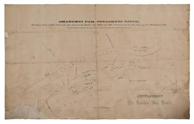
Plan, Ōmarunui Pā
Maker
Hawke's Bay Herald
Current rights
All Rights Reserved
See full details
Object detail
Brief Description
Plan of Ōmarunui Pā, Tutaekuri River. Hawkes Bay Herald supplement. The map shows the scene of the conflict which took place between the Hawke's Bay Militia, the Rifle Volunteers and Pai Mārire on October 12, 1866. Noted are the positions of the Volunteers, Militia and Northern Māori Contingent on the north side of the Tutaekuri River; Militia - No 1 and No 2, burial ground of twenty one Pai Mārire, Parnapa's tent and the site where the flag of truce was erected on the south side of the river.
Also noted are the locations of the Māori whare and the area where Private Young died.
Also noted are the locations of the Māori whare and the area where Private Young died.
Production technique
Media/Materials description
Printed on paper with linen backing
Media/Materials
Measurements
Unmatted: Height x Width: 315 x 505mm
Classification terms
Subject period
Subject date
12 Oct 1866
Current rights
All Rights Reserved
Credit line
gifted by Dr Grant Taylor
Other number(s)
50/53, 5106, 71149
Accession number
50/53


Public comments
Be the first to comment on this object record.