Plan, Clive Grange Domain
Production date
Circa 1939
Current rights
Public Domain
See full details
Object detail
Brief Description
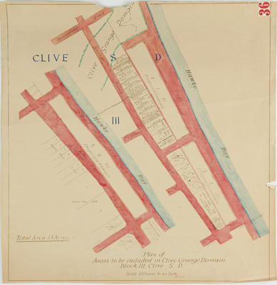
Plan, Clive Grange Domain. Circa 1924.
Plan of areas to be included in Clive Grange Domain Block III, Clive SD.
Total area of 13 acres.
Shows lot numbers with owners names, eg Mary Jane Ramsey, Certificate title No 22/171, Margaret Mills, Certificate title No 47/111, Jeanie Aiton Baird, Certificate title No 49/28.
Shows the public road, Grange Road and Springfield Road areas.
Production date
Circa 1939
Production place
Production period
Production technique
Media/Materials description
Hand drawn on paper in black, blue and red ink.
Media/Materials
Measurements
Height x Width: 530 x 515mm
Signature/Inscription
#36, Stamp
Classification terms
Subject period
Subject date
Circa 1924
Current rights
Public Domain
Caption
Collection of Hawke’s Bay Museums Trust, Ruawharo Tā-ū-rangi, 70721
Credit line
gifted by the Hawke's Bay County Council
Other number(s)
m60/36, 5385, 70721


Public comments
Be the first to comment on this object record.