Map, Province of Hawke's Bay
Maker
Koch, Augustus
Production date
1864
Object detail
Brief Description
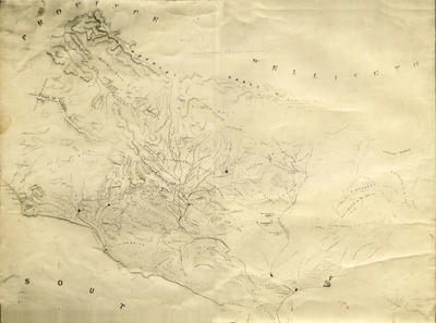
Copy of a map of the Hawke's Bay area of the Province of Wellington, 1864.
Lists the individual plot (section) numbers.
The map shows the Ruahine Ranges, Ruataniwha Plains, Pukititiri (Puketitiri) Bush, Reserve for Military Settlement, Pohui Bush, Tikokino Reserve, Town of Hampden (Hastings), Township of Porangahau, Poporangi, Puke Toi (Puketoi), Patangata, Kaweka Range, Tukituki and Ngaruroro Rivers, Omahu Pa, Blackhead, and Waipawa.
Land owners listed: T Lowry, A Newman, H S Tiffen, J Rhodes, H S Hill, Chambers, R Foster, W Courer, Weston & Buchannan, E S Curling, H S Tiffen, H W Smith, R France & Miller, Richardson & Troutbeck, Whitmore & McNeill, J Taylor, J Parson, S Begg, J Hallett, H W P Smith, J N Williams, W Lyon, H A Duff, G G Carlyon, T Mason, R & J M Stoley, F S Abbott, C S Cooper, W Fannin, J Harding, T Tanner, J.R Duncan, C J & H Nairn, K Gollan, D Gollan, E Collins, R Collins, A H Russell, T P Russell, D McLean, J Tucker, C Lambert, J Roy, W Couper sen., J D Ormond, J Tanner & Price, Speedy, J C L Carter, W S Rhodes & A Chapman, A St. C Inglis, C Hunter, J Johnston, A Grant.
Production date
1864
Production period
Production technique
Media/Materials description
Photocopy.
Media/Materials
Measurements
Height x Width: 390 x 610mm
Classification terms
Subject person
Subject period
Subject date
1864
Credit line
gifted by R D Speedy
Other number(s)
m74/12, 5675, 70402
Public comments
Be the first to comment on this object record.