Plan, Westshore Extension
Production date
1942
Object detail
Brief Description
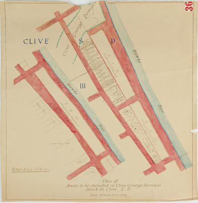
Plan, Westshore Extension, No 23, Hawke's Bay. 1942.
Being parts of Napier sub section 664, the Ferry Reserve, Harbour Reserve, and Westshore sections 1 & 2, Heretaunga S D block IV.
Plan shows lots, lot numbers, area sizes, roads, Reserves.
Twelve lots border Meeanee Quay, 6 blocks border Charles Street. Ferry reserve borders the public reserve, by the Iron Pot.
One chain to the inch.
Production date
1942
Production period
Production technique
Media/Materials description
Hand drawn on tracing paper backed with linen in red and black ink.
Media/Materials
Classification terms
Subject period
Subject date
19 Jan 1942
Credit line
gifted by the Hawke's Bay County Council
Other number(s)
m60/36, 5387, 69609
Public comments
Be the first to comment on this object record.