Map, Kuripapanga, Patea, Hawke's Bay
Maker
Bold
Production date
1878
Object detail
Brief Description
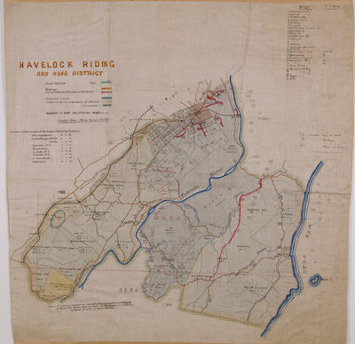
Map, Kuripapanga, Patea, Hawke's Bay. 1875.
Sketch map showing the country in the vicinity of Kurupapanga [Kuripapango] Road and the area from Atamakopiri stream in the South to the Waiherekeke stream in the East.
Plan shows the line of the road laid off and levelled, line of alternatives recommended for adoption, bridle paths and a line reconnoitred but discarded as probably too expensive.
Ngaruroro River runs through the area from South to North.
Maker
Production date
1878
Production period
Production technique
Media/Materials description
Hand drawn on paper, backed with linen in black, green, red inks.
Media/Materials
Measurements
Height x Width: 670 x 975mm
Signature/Inscription
54, Stamp
Classification terms
Subject person
Subject period
Subject date
Aug 1875
Credit line
gifted by Hawke's Bay County Council
Other number(s)
m60/36, 5366, 69596
Public comments
Be the first to comment on this object record.