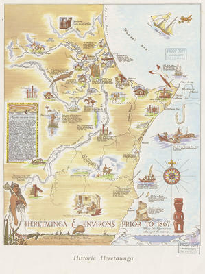
Map, Historical Heretaunga and Environs
Maker
Phillips, H Eric
Production date
1947
Current rights
Public Domain
See full details
Object detail
Brief Description
Map, Historical Heretaunga and Environs prior to 1867. Drawn by H Eric Phillips.
Descriptive map of Heretaunga Plains and environs when the Ngaruroro River changed its course, prior to 1867. Map shows the area from Karamea in the South to Otatara in the North and Paki Paki to the West. Various printed notations can be seen about early Māori history. Notation above Cape Kidnappers explains that on October 16,1769 Captain Cook in the Endeavour lay off Matua Maui and named it Cape Kidnappers.
Descriptive map of Heretaunga Plains and environs when the Ngaruroro River changed its course, prior to 1867. Map shows the area from Karamea in the South to Otatara in the North and Paki Paki to the West. Various printed notations can be seen about early Māori history. Notation above Cape Kidnappers explains that on October 16,1769 Captain Cook in the Endeavour lay off Matua Maui and named it Cape Kidnappers.
Maker
Production date
1947
Production period
Production technique
Media/Materials description
Printed on light card in coloured inks.
Measurements
Height x Width: 445 x 410mm
Classification terms
Subject period
Subject date
1867
Current rights
Public Domain
Credit line
gifted by D Nelson
Other number(s)
m61/7, 5358, 69589


Public comments
Be the first to comment on this object record.