Map, Havelock North
Maker
Scott, L W
Current rights
Public Domain
See full details
Object detail
Brief Description
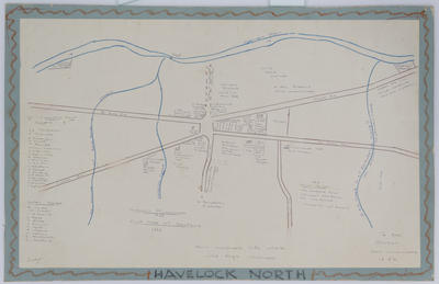
Map of Havelock North, Hawke's Bay.
Drawn by L W Scott.
The map shows Middle, Toll, Te Mata and Napier Roads.
Individual plots are listed along with their first owners:
R H MacGregor, T Triphock, J Anderson, A Wyatt, P Rourke, William Colenso, J Wilkinson, N Campbell, H Stark, J McKinnon, J Smith, J Robottom, W Pelliett, J Fouqere, A.P Stuart, A Kennedy, H Webster, J. Ferqueson and F Dyett.
Second ownership:
E Jones, A H Russell, W Gisbourne, S Begg, T Blake, J Francon, T Mould, A Woking, W Cellum, G Henderson and E Strafford.
Maker
Production technique
Media/Materials description
Drawn in coloured pencil on paper mounted to card.
Measurements
Height x Width: 480 x 740mm
Classification terms
Subject person
Current rights
Public Domain
Caption
Collection of Hawke's Bay Museums Trust, Ruawharo Tā-ū-rangi, m75/8
Other number(s)
5681(a), m75/8, 69498


Public comments
Be the first to comment on this object record.