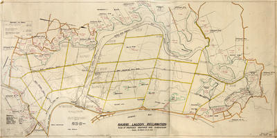
Plan, Ahuriri Lagoon
Maker
Halley, David John Bruce
Mayhead, H
Production date
Nov 1934
Current rights
Public Domain
See full details
Object detail
Brief Description
The plan of the Ahuriri Lagoon reclamation for proposed drainage and subdivision. The plan shows gravity drains, dewatering drains, boundaries, public roads, proposed roads, existing drains and water courses around Wharerangi Road, Wharerangi block, Napier to Westshore bridge, Ahuriri Lagoon, Matawhero, Awa-a-Waka and Tuteranaki.
The main gravity outfall is shown around the Maraetara-Wharerangi block exiting out under the Westshore bridge. The lagoon reserve consists of 7,753 acres, catchments outside the lagoon reserve total 24,089 acres, areas to be gravity drained total 26,037 acres and there are 5,805 acres to be drained by pumping.
J Vigor Brown has property adjoining the Taipo Creek near Park Island and R D & L D Holt own land by Maraetara.
Engineer, D J B Halley.
Date, November 1934
Production date
Nov 1934
Production place
Production period
Production technique
Media/Materials description
Drawn on linen with coloured ink.
Media/Materials
Measurements
Height x Width: 760 x 1610mm
Classification terms
Subject person
Subject period
Subject date
1935
Current rights
Public Domain
Caption
Collection of Hawke's Bay Museums Trust, Ruawharo Tā-ū-rangi, [69070]
Other number(s)
m73/62, 5674, 69070


Public comments
Be the first to comment on this object record.