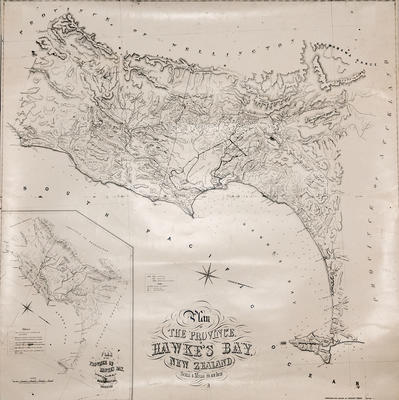
Plan, copy, Hawke's Bay
Current rights
Public Domain
See full details
Object detail
Brief Description
Copy of an 1864 plan of Hawke's Bay by cartographer Augustus Koch showing crown land, land sold, Māori land and reserves, roads, settlements around Mahia Peninsula, Waikare River, Kaweka Range, Ngatarawa plains, Napier and Cape Turnagain.
P Dolbel has land adjoining the Mohaka River, near the Mangaharuru Range, J Rhodes has land around Clive, H Tiffen has land in Meeanee, J C Gordon owns land on the arm that forms Cape Kidnappers and J D Ormond is a land owner adjoining the Eparaima Māori reserve near the Manga Whero Stream in Central Hawke's Bay.
An inset map shows the geological formation of Hawke's Bay.
Production place
Production technique
Media/Materials description
Printed on paper with linen backing and black ink.
Media/Materials
Measurements
Height x Width: 865 x 850mm
Classification terms
Subject person
Subject period
Subject date
1864
Current rights
Public Domain
Other number(s)
69018


Public comments
Be the first to comment on this object record.