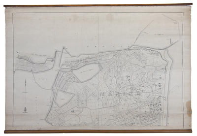
Map, Borough of Napier
Maker
Humphries, Thomas
Department of Lands & Survey
Production date
1908
Current rights
Public Domain
See full details
Object detail
Brief Description
The cadastral map of the Borough of Napier shows land lots, area sizes, streets, reserves around the Inner Harbour and the Western Spit. The Port Ahuriri lagoon adjoins Battery Road, Raglan Street and Bridge Street.
The Troopers Memorial to men who fought in the Boer War, erected in 1906, is shown on Marine Parade. The Garrison (drill) hall is located on Coote Road. [In correspondence dated 1910, chief surveyor C R Pollen confirms that this map shows the drill hall building in the wrong place].
The Flood Memorial stands on the corner of Marine Parade and Byron Street near the police station. The North British & Hawke's Bay Freezing Works are next to the channel entering the Inner Harbour.
Production date
1908
Production place
Production period
Production technique
Media/Materials description
Printed on paper and backed with linen.
Media/Materials
Measurements
Height x Width: 835 x 1215mm
Classification terms
Subject period
Subject date
Circa 1908
Current rights
Public Domain
Credit line
gifted by R Northe
Other number(s)
5380 (a), m61/28 (a), 68953


Public comments
Be the first to comment on this object record.