Topographical Map, upper North Island
Maker
Dick, R G
Paul, E V
Department of Lands & Survey
New Zealand Government
Production date
1944
Current rights
Public Domain
Object detail
Brief Description
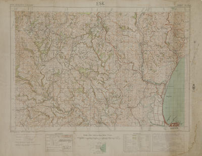
Topographical Map of the upper North Island.
Shows aerodromes, roads, rivers, sea plane mooring areas, seaplane stations around the Hawke's Bay area, from Whakatane, Gisborne, Frasertown, Rotorua, Lake Taupo, Napier, Waipawa, Waipukurau to Wanganui to the south west. An index map of New Zealand included, noting that New Zealand flying strip has the code letters ZF, ZS and ZD.
Shows aerodromes, roads, rivers, sea plane mooring areas, seaplane stations around the Hawke's Bay area, from Whakatane, Gisborne, Frasertown, Rotorua, Lake Taupo, Napier, Waipawa, Waipukurau to Wanganui to the south west. An index map of New Zealand included, noting that New Zealand flying strip has the code letters ZF, ZS and ZD.
Production date
1944
Production place
Production period
Production technique
Media/Materials description
Printed on paper and backed with linen. Colour and black ink.
Media/Materials
Measurements
Height x Width: 880 x 620mm
Classification terms
Subject period
Subject date
1944
Current rights
Public Domain
Other number(s)
7543, 68857
Public comments
Be the first to comment on this object record.