Map, Napier County districts, Hawke's Bay
Maker
Hamel & Ferguson Printers
Rochfort, James
Lyndon, Edward
Production date
Circa 1876
Object detail
Brief Description
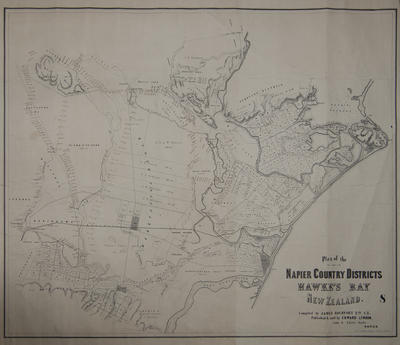
Map of Napier County districts, Hawke's Bay. Shows district areas and boundaries, land blocks or lots and their sizes, railway lines, rivers, coastal areas and swamps.
The map covers an area from Omarunui block and Waitio River in the North, to Ngaruroro River and Havelock North area in the South; and from Tukituki River, Clive, Napier and Puketapu area in the East, to Ngatarawa block 4, Turamoe, Kakiraawa and Te Mata district in the West.
Napier town is marked as a small settlement at the base of Scinde Island. Western Spit (Westshore), the bar to the entrance of the inner harbour entrance and Eastern Spit (Ahuriri) are noted bounding Gough Island. South of Ahuriri harbour, the area of Te-Whare-O-Maraenui (1788 acres), lies between the Tutaekuri River outflow and Awatoto. A block of 10 acres belonging to Tareha is noted bordering the Tutaekuri River, and a toll gate is noted at Awatoto.
Taradale and Meeanee have been subdivided into approximately 30 blocks of 50 to 70 acres each, bordering the Tutaekuri River and extending out to Salt Water Creek outlet by Balmoral at the harbour's edge. C Mitchell has a parcel of land (19 acres), bordering the Tutaekuri River, near Pukeroa and the racecourse, which in turn is near Waitangi Creek. Pā Whaikairo and a large block of native land are noted next to the Tutaekuri River.
J B Brathwaite occupies a large block of land bordering the Omarunui block and Repo-Ki-Te - Roto-Roa Stream, and other land of his is around Lake Roto Hare (totalling 3573 acres). The Omaku Mill is nearby.
R D Maney has land on the Waipiropiro block of 1197 acres. AH & W Russell own 2 large blocks bordering the Waitio River and J D Ormond's land. J G Gordon has land bordering A H & W Russell's land. J N Williams is to the other side of J D Ormond's land, consisting of 2260 acres. His land borders the Ohiwia Stream.
S Roe (300 acres), M Groome, G Hamilton, J Boyle and F Hicks are land occupiers in a small rural area of approximately 700 acres in the area that became Hastings. The Makirikiri Stream runs through some of their properties. Hastings railway station, which was built in 1873, is marked on land owned by F Hicks.
Thomas Tanner owns land bordering Hastings and the Te Mangapouri Stream. Karamu Pā is noted on the Karamu Reserve, next to the Ngaruroro River roughly southeast of the railway line and Hastings.
J Chambers is a land owner on block 9, Te Mata District, T P Russell and R Foster have land in Havelock North, bordering Middle Road. R D Mancy has land on Puri Whariki at the confluence of the Te Awahou Stream and the Tutae-kuri-Wai-Mate Stream.
Production date
Circa 1876
Production place
Production period
Media/Materials description
Printed on paper backed with linen, with black ink.
Media/Materials
Measurements
Height x Width: 775 x 910mm
Classification terms
Subject person
Subject period
Subject date
Circa 1876
Credit line
gifted by R G Montgomery
Other number(s)
5284, m58/72, 64846
Public comments
Be the first to comment on this object record.