Photocopy of Map of the Province of Hawke's Bay
Current rights
Public Domain
Object detail
Brief Description
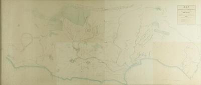
Black and white photocopy of Map of the Province of Hawke's Bay or Late District of Ahuriri, originally lithographed in 1859 by C M Igglesden and E Anderson, Surveyors, Wellington.
The map shows native reserves, land acquired by the Government, boundary of runs, boundaries of purchases, roads and tracks from the Mohaka block - 85,700 acres around Putorino and Waikare, Port Napier, Kidnapper block, Hapuku block, Ruataniwha, Porongahau block and Seventy Mile Bush at the Southern end by Wangahu, Cape Turnagain and the Mangawhero Stream.
Run holders names include:
D Gollan - Land owner South East of Waipukurau, near the Tangi Te Poro Stream.
J N Northwood - Near Oeroa, West of Blackhead.
E Collins - Borders the river Alina or Tukituki River in the Hapuku block.
J Monteith - Land owner on the Waipukurau County border, around the Maunga Rahi Kahi near Oero, which is East of the Tukituki River.
W Couper - Land owner around Arama's block, Hawea and bordering the Tukituki River West of Waimarama.
J Chambers - Borders W Couper to the South and G Moore to the North, by the Tukituki River.
H S Tiffen - Land owner around the Hapuku block, near Roto Atera and the Kai Koura track.
A St Hill - Land owner at Te Awanga, bordering the Kidnapper block and the Tukituki River.
Rhodes - Has the land on Cape Kidnappers peninsula.
H R Russell - Neighbours D Gollan and A Newman, South of Hatuma Lake.
D McLean - Land owner near Aorangi which is next to Huranga O Te Pangi and the Aroha road/track.
T P Russell - Land owner near Maharakeke, bordering Tukituki River and Lake Hatuma.
A Alexander - Borders Mangaone River, Tutaekuri River in the Puketapu area.
William Villiers - Land owner West of the Esk River, bordering the Mangaone River and J C Carter, North West of Port Ahuriri.
W Ogilvy - Land owner on the other side of the Mangaone River between the Waiau and Wai Iti or Mangahouhou River.
H B Sealey - Land owner on the Ahuriri block bordering the Mangaone River.
The roads are paper roads. The map has no geodetic framework so it is inaccurate in scale and position inland.
Production technique
Media/Materials
Measurements
Height x Width: 1500 x 685mm
Classification terms
Subject person
Subject period
Subject date
1859
Current rights
Public Domain
Other number(s)
5000(a), 64725
Public comments
Be the first to comment on this object record.