
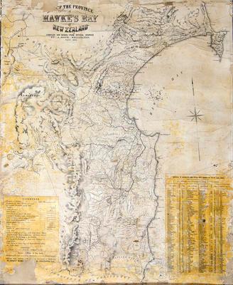
Map, Hawke's Bay, 1874
Maker
Koch, Augustus Karl Frederick
Production date
Circa 1874
Current rights
Public Domain
See full details
Object detail
Brief Description
Map of Hawke's Bay, 1874. Compiled and drawn from official sources by Augustus Koch, Wellington.
Four miles to the inch.
Shows boundaries of provinces, Government purchases, townships, lands ceded to the Government by Natives from Mahia, Wairoa, Mohaka at the Northern end, Taupo Lake, Kaimanawa Ranges to the West and Napier, Kaikora, Waipukurau and Woodville East and Southwards.
D McLean has a land block in the province of Wellington, bordering the Akiteo River, M S Bell - Tautane block, Wainui, G Hunter has land in and around Porangahau, J D Ormond neighbours him to the West in Wallingford. J Johnston has land at Takapau, bordering the Manawatu River and the tramway to Waipukurau.
T P & H R Russell have most of the land surrounding Waipukurau and Lake Hatuma. C & J Nairn, D Gollan, J Johnston, J Rhodes, R Curling have the land that is in the Patangata district and Tamumu, South of Havelock and East of Kaikora bordering the Mangakuri River and Blackhead areas. Campbell & Meinhcrzhagen have land on the Waimarama block, directly West of Bare Island. J Gordon owns the land on Cape Kidnappers spit, bordering the Maraetotara River.
G G Carlyon has the land around Gwavas and Mangaonuku River, T Lowry borders Lake Okawa and Woodthorpe. W T Buckland owns land in the Puketapu district near Pekapeka, A McLean & G S Whitmore neighbour J Gordon of the Cape Kidnapper land and Clive and Tukituki River.
The track to Fort Galatea branches off at Opepe, heading North East. A Pai Mārire settlement is noted next to the Hinemaiai River, where tracks are shown leading to Motu Taike - the island on Lake Taupo and Tokane. A Native church & ferry are shown bordering the Taupo road and Mohaka River near Te Haroto where a blockhouse is located.
A stockade is shown at Runanga where H Hilliers homestead is noted.
The Hawke's Bay boundary is shown starting at a boat harbour at Mahanga to the North, extending west to the Kaimanawa bush - near Tarawera, South along the Kaweka Range to Pikirangi, Matawhero and down to the Manawatu Gorge near Woodville and East to Cape Waimate.
Robert Rhodes & Co have a large tract of land surrounding the Puketitiri bush, Tutaekuri River and Patoka. H W P Smith has land bordering Aorangi, Ngaruroro River and Kereru.
The railway line south from Hastings runs as far as the Ruataniwha Plains, South West of Lake Hatuma, some 5 miles from Norsewood.
A schedule of blocks of land which have passed the Native Land Court is included.
Production date
Circa 1874
Production place
Production period
Media/Materials description
Drawn and printed on paper backed with linen. Ink. Two wood battens top and bottom.
Media/Materials
Measurements
Height x Width: 1080 x 835mm
Classification terms
Subject person
Subject period
Subject date
1874
Current rights
Public Domain
Other number(s)
5007, 5615, 64705
Public comments
Be the first to comment on this object record.