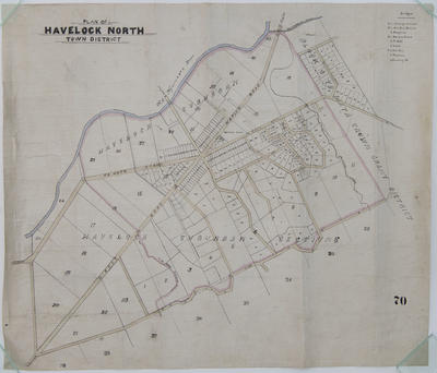
Map, Havelock North
Current rights
Public Domain
See full details
Object detail
Brief Description
Map of Havelock North town district.
Shows land lots, streets and the Ngaruroro River, around Cemetery Road, Middle Road, Te Aute Road, Te Mata Road and Napier Road. The Ngaruroro River borders lots and block 9, Te Mata crown grant district. At the top is a key noting bridges:
Herihere Stream - Te Aute Road.
Danvers Creek - Napier Road.
Production place
Production technique
Media/Materials description
Drawn and printed on linen. Ink.
Media/Materials
Measurements
Height x Width: 740 x 865mm
Classification terms
Subject date
Unknown
Current rights
Public Domain
Other number(s)
5276, 64607


Public comments
Be the first to comment on this object record.