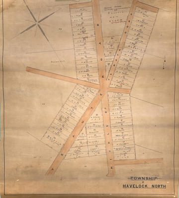
Cadastral map, Township of Havelock North
Production date
Circa 1913
Current rights
Public Domain
See full details
Object detail
Brief Description
Cadastral map of the Township of Havelock North.
Shows lot numbers, area sizes, boundary lines around the Middle Road, Te Aute Road and Te Mata Roads. A H Russell, J B Ferguson, P Bourke, S Begg, A Kennedy, W Reardon, A Wyatt, J N Wilson, A P Stuart all have adjacent land fronting Te Mata Road, near the Middle Road intersection.
J Robottom, A H Russell, T H Fitzgerald, T Blake, Mary Muir, J Bray, F Mould, Jessie Fitzgerald, W H T B Pilliet, Jean Franeon, P Bourke, J A Smith, J R Percy and H P Stark have adjacent land fronting Middle Road.
W Colenso has land on the corner of Te Aute & Middle Road, A H Russell, J R Perry, M Fitzgerald, W Reardon, F Mould, H Webster, James Fougere, J A Smith, W Cellum, F Dyett have adjacent land lots fronting Te Aute Road and the police station reserve is on lot 79, next to F Dyett and fronting Te Aute Road.
Other names noted are Bishop Abraham - Middle Road, William
Gisborne, Taylor Gardiner.
In red ink, handwritten: N Z G N No 26 - 26 April, 1888.
In black ink, handwritten: Gazette 1913, August.
Noted from a map of the area that first sales of sections were around 1860, which included these names.
Production date
Circa 1913
Production place
Production period
Production technique
Media/Materials description
Printed on paper with linen backing. Ink.
Media/Materials
Measurements
Height x Width: 590 x 525mm
Classification terms
Subject person
Subject period
Subject date
Apr 1888
Pre 1913
Pre 1913
Current rights
Public Domain
Other number(s)
7530, 60754


Public comments
Be the first to comment on this object record.