Map, Folder of plans and maps of Napier Reclamation Proposals
Maker
Public Works Architectural Branch
Walshe, Harry Edward
Department of Lands & Survey
Brook, T
Neill, W T
Skinner, W A G
Brett Lithography
Finch, Frank
Herald Lithography
Rochfort, Guy
Production date
1920-1929
Object detail
P.W 2146/1, Napier. C.D.E M86. file 10/63.
1) Map showing Hawke Bay, Napier South, Ahuriri Lagoon, Western endowment area, Eastern endowment area. Noted is a suggested artificial lake in the Western Endowment area.
Shown also is the Tutaekuri River before it was diverted to Waitangi Creek area.
2) Cadastral map - REF: 250-L11955-24.
Shows land lots, area sizes, rivers, swamps, towns around Hastings, Ngaruroro River, Tutaekuri River, Napier, Ahuriri Lagoon, Matapiro district, Omarunui and Taradale board district. Some place names along the Ahuriri Lagoon waters edge are Rauwera, Kirikiri - O - Tamaki, Ohuarau, Hinewaka and Te Niha. Nga Muku Island can be seen near the railway line near the Western Spit. Tapu Te - Rangi - Watchman, is noted near Wharerangi.
3) Handwritten manuscript - Napier Harbour and township, Napier town and port. Fill quantities. It is also noted on page 1 that:
A comparison of the towns of the dominion shows that, if in the consideration of the permissible residential density of 750 persons to 100 acres is fixed as the maximum, Auckland is the first then Napier and Christchurch third ie: Napier - 977, Auckland - 1003 and Christchurch - 963. If the available residential area is to keep pace with the increase in population in Napier, it is estimated that Napier will need to find 500 acres annually and is already 500 acres in arrears.
4) Map, Napier Harbour Board proposed Inner Harbour extension and reclamation areas. Inner Harbour scheme recommended by Keele & Cullen, consulting engineers. Adopted by Harbour Board, 1912.
Shows areas to be dredged to a uniform depth, areas to be reclaimed, works to be commenced first and future works around the Ahuriri Lagoon, inner harbour, Ahuriri and harbour board endowment area near Maraenui Road. Thirty eight acres near Waghorne Street and 22 acres near Lever Street are to be reclaimed. Notes the possible railway yards by the embankment and Hyderabad area and shows the first area to be dredged to give 34 feet. Also notes depth soundings around the harbour area. The telegraph and signal station is shown around the Coote Road area on the hill.
5) Manuscript, Vote for the Inner Harbour Loan and advance Hawke's Bay. A Harbour with no rates.
6) Map, Napier Harbour Board, Suburban Planning Competition, 1921. Shows Scinde Island, inner harbour, East Coast railway line to Wairoa, harbour board endowment , Te Whare o Maraenui and the proposed station and railway yard site adjoining Georges Drive and the Tutaekuri River. The proposed tram route to Taradale is shown. The old Petane bridge which is to be removed is also noted, as well as the future Westshore railway station.
7) Map, Napier Harbour Board suggested site for future railway yards and station, 1920. Shows Scinde Island, Westshore, Napier South, Hawke's Bay board endowment areas, future wharves at Ahuriri and the Glasgow wharf. In pencil is noted the station - yards - 70 acres.
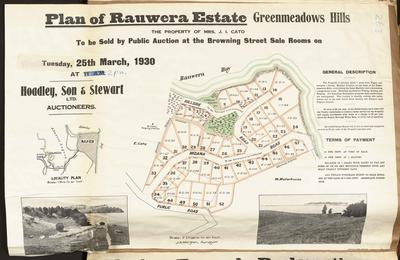
8) Plan, Napier Harbour Board important sale of leases. 72 sections of town and suburban lands will be offered for lease at public auction by Hoadley, Son & Stewart Ltd at the Williams & Kettle sale rooms on Monday, December 22 1924.
Shows land lots with area sizes around Hastings Street South - Te Awa Avenue, Ellison Street, Georges Drive, Battery Road, Waghorne Street and Outram Street.J Mc Farlane owns land at section 94 near Burns Terrace and C Brown owns land adjoining Burns Road.
9) Map, Napier Harbour Board Proposed Inner Harbour extension and reclamation areas. 1919.
10 - 23) Maps, showing Napier South, Inner Harbour; Western and Eastern Endowments. The fourteen maps are the same.
Height x Width: 430 x 530mm
Height x Width: 340 x 220mm
Height x Width: 558 x 935mm
Height x Width: 280 x 210mm
Height x Width: 748 x 950mm
Height x Width: 525 x 645mm
Height x Width: 555 x 855mm
Height x Width: 555 x 920mm
Height x Width: 460 x 580mm
Public comments
Be the first to comment on this object record.