
Map, Seat of War in South Africa
Maker
Department of Lands & Survey
Flanagan, F W
Smith, Stephenson Percy
Production date
1899
Current rights
Public Domain
See full details
Object detail
Brief Description
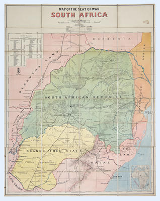
Map of the Seat of War in South Africa.
Map enclosed in a booklet.
Shows railways, coach routes, gold fields, coal fields, altitudes in feet, from Bechuana land, Rhodesia at the North, South African republic, Portuguese East Africa, Cape colony, Orange Free State, Natal and Zulu Land. Gold fields are noted at Little Letaba, Pietersberg and Klerksdorp in the South African Republic. Noted in Zulu Land - Prince imperial killed June 1879, near Rorke's Drift. Ingogo February 1881. An index of railway mileages is included.
The following is handwritten on the inside cover:
Mrs W Withers, Palmerston North, New Zealand.
-72-
A.J.W - No 1.
Production date
1899
Production place
Production period
Production technique
Media/Materials description
Paper glued to linen; coloured map. Printed on paper with black and coloured ink.
Media/Materials
Measurements
Height x Width: 1024 x 740mm
Height x Width: 195 x 130mm
Height x Width: 195 x 130mm
Classification terms
Subject period
Subject date
1899-1901
Current rights
Public Domain
Credit line
gifted by Mr Norman Harvey
Other number(s)
m60/14, 5349, 50801
Public comments
Be the first to comment on this object record.