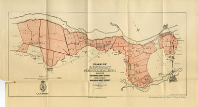
Booklet and map, Lindsay Settlement
Maker
Department of Lands & Survey
Production date
Apr 1905
Current rights
Public Domain
See full details
Object detail
Brief Description
Booklet and map of Lindsay Settlement (near Waipawa).
Contents include: general description of Lindsay Settlement; directions to applicants; schedules of sections, areas, and rentals; detailed descriptions of sections for disposal as ordinary farms; detailed descriptions of sections for disposal as farms of mixed agricultural and pastoral land; detailed descriptions of sections for disposal as suburban allotments; two maps, one a locality map, the other a map of the settlement.
Lindsay Settlement comprises: Blocks IV & VIII of Ruataniwha Survey District and Blocks V, X, XI, XIV & XV of Waipukurau Survey Districts.
Maps folded up in the back of a small booklet.
Collection
Production date
Apr 1905
Production place
Production period
Production technique
Media/Materials description
Printed on paper with black and red ink. Stapled.
Media/Materials
Measurements
29 pages: Height x Width: 215 x 140mm
Classification terms
Subject person
Subject period
Subject date
Apr 1905
Current rights
Public Domain
Credit line
gifted by Williams & Kettle
Other number(s)
m2007/86/94, 6569, 46693


Public comments
My Great Great Grandmother, Lottie Blake, won the right to lease Section XIV Block 5 of Lindsay Settlement in a ballot. The ballot winners are published in this Papers Past article: https://paperspast.natlib.govt.nz/newspapers/NZMAIL19050419.2.70?end_date=31-12-1908&items_per_page=10&query=Lindsay+settlement+Lottie+Blake&snippet=true&start_date=01-01-1905&type=ARTICLE
- Geoff T Beals posted 3 years ago.