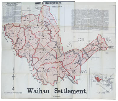
Map, Waihau Settlement
Maker
Department of Lands & Survey
Production date
11 Mar 1913
Current rights
Public Domain
See full details
Object detail
Brief Description
Map of Waihau Settlement, Hawke's Bay Land District No 293. 11 March 1913.
District bounded by Tutaekuri River; Mangatutu River, property owned by F Thompson, J Walker, T E Crosse, W F H Berkahn, F Hutchinson, L W North.
Other property owners' names have been added, including J Alexander, B C Williams, D Dobson, R B Burgess, H Halliwell, J W McRobbie, Michael Hogan, Patrick Butler, H Hartree, J Waldon, P Howard.
Close to Rissington and Patoka. The Waihau Settlement comprises the estates formerly known as Waihau, Ngaroto, and Peka Peka and is bounded on the south by the Tutaekuri River and on the west by the Mangatutu Stream. 19 miles from Napier, 3 miles from Rissington School and Post Office. The Waihau Stream and its tributaries run through the block. Includes detailed descriptions of sections.
Folded up to form a small booklet.
Collection
Production date
11 Mar 1913
Production place
Production period
Production technique
Media/Materials description
Printed on paper with black and red ink. Blue linen cover.
Media/Materials
Measurements
Height x Width: 792 x 945mm
Classification terms
Subject person
Subject period
Subject date
11 Mar 1913
Current rights
Public Domain
Caption
Collection of Hawke's Bay Museums Trust, Ruawharo Tā-ū-rangi, m2007/86/91
Credit line
gifted by Williams & Kettle
Other number(s)
m2007/86/91, 6566, 46466


Public comments
Be the first to comment on this object record.