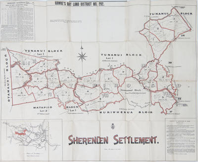
Map, Sherenden Settlement
Maker
Williams & Kettle Ltd
Department of Lands & Survey
Production date
26 Feb 1913
Current rights
Public Domain
See full details
Object detail
Brief Description
Map of Sherenden Settlement, 26 February 1913. District bounded by Otamauri Block (George Orme Bayley owner), Tunanui Block (A M Shield, A H Russell Junior, T S Percival, owners), Matapiro Block Lot 1 (William Nelson owner) and Lot 2 (H N Coleman owner); Muriwhenua Block (T H Lowry owner); Mangatarata Stream. The new owners have been penciled in. The Sherenden Settlement is situated on both sides of the Main Hastings-Patea Road. The nearest point of settlement from the town of Napier is twenty miles and thirty-one miles from Hastings. Has writing on top left hand corner and bottom right hand corner. Folded up to form a small booklet.
Collection
Production date
26 Feb 1913
Production place
Production period
Production technique
Media/Materials description
Printed on paper with black and red ink. Brown linen cover.
Media/Materials
Measurements
Height x Width: 785 x 912mm
Classification terms
Subject person
Subject period
Subject date
26 Feb 1913
Current rights
Public Domain
Credit line
gifted by Williams & Kettle
Other number(s)
m2007/86/90, 6565, 46464


Public comments
Be the first to comment on this object record.