Map, Woodville
Maker
Department of Lands & Survey
Production date
10 Dec 1874
Current rights
Public Domain
See full details
Object detail
Brief Description
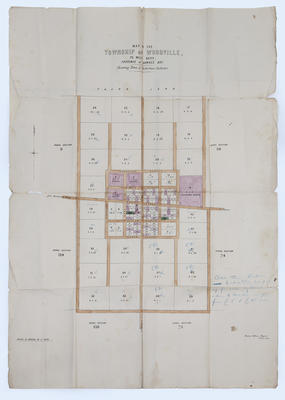
Map of the township of Woodville, 70 Mile Bush, Province of Hawke's Bay.
The map shows the town and suburban sections; the road from Manawatu Gorge to Napier; Richardson, Atkinson, Vogel, Fergusson, Grey, Ormond, Ross, Pollen and Bowen Streets, with sections detailed. The map also shows rural sections and Crown land next to the township. Some sections have blue pencil marks on them. There is a note handwritten in blue pencil: All town sections tinted blue will be put up for sale by auction within 4 months at prices from five pounds & fifteen pounds each.
The map is printed in black ink on paper, with sections coloured with watercolour, and handwritten annotations. Published by the Survey Office, Napier. 10 Dec 1874.
Written in pencil on reverse side: Woodville Original Plans.
Collection
Production date
10 Dec 1874
Production place
Production period
Production technique
Media/Materials description
Paper, black ink, blue coloured pencil, watercolour
Media/Materials
Measurements
Height x Width: 880 x 550mm
Signature/Inscription
Survey Office, Napier. 10th Dec 1874, Manufacturer's Details, Printed
Woodville Original Plans, Inscription, Handwritten
Woodville Original Plans, Inscription, Handwritten
Classification terms
Subject person
Subject period
Subject date
10 Dec 1874
Current rights
Public Domain
Caption
Collection of Hawke's Bay Museums Trust, Ruawharo Tā-ū-rangi, [31197]
Credit line
gifted by anonymous
Other number(s)
m2004/19, 31197


Public comments
Be the first to comment on this object record.