Plan, portion of the Apley Estate
Maker
Rochfort, James
Production date
Nov 1880
Object detail
Brief Description
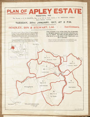
Plan of portion of the Apley Estate.
Twenty chains to the inch.
Shows number 73 block subdivided around the Mangaone River, Tutaekuri River. Block 73 has a total of some 2,500 acres.
Written bottom left hand corner is: This plan is compiled partly from a survey made by Messrs Ellison, partly from the Government plan of the Puketapu district and partly from a survey made by myself of certain fences, the bearings of the lines of which fences are shown. Signed by James Rochfort.
Production date
Nov 1880
Production place
Production period
Production technique
Media/Materials description
Handwritten and hand drawn in ink and watercolours. Artist's paper.
Media/Materials
Measurements
Length x Width: 685 x 735mm
Classification terms
Subject person
Subject period
Subject date
Nov 1880
Other number(s)
6381, 31150
Public comments
Be the first to comment on this object record.