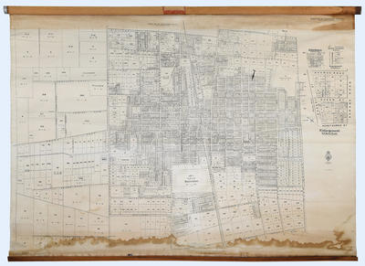
Map, Borough of Hastings

Maker
Skinner, W A G
Department of Lands & Survey
Thompson, J D
Wicks, A J
Walshe, Harry Edward
Production date
1931
Current rights
Public Domain
See full details

Object detail

Brief Description
Map of the Borough of Hastings.
Sheet Number 1 & 2 joined.

Enlargement of the central city - Russell, Queen, Market, Eastbourne & Heretaunga Streets and Karamu Road. Map shows racecourse, railway line, Beatson's Park. Developed area from Pakowhai and Maraekakaho Roads to Norton Road; Williams Street and Collinge Road to Tollemache Road. The undeveloped area shown out from Pakowhai & Maraekakaho Roads to York Road.
Production date
1931
Production period
Production technique
Media/Materials description
Cartographer's paper glued onto linen; wooden supports top and bottom. The top railing has aluminium and steel attachments for hanging the paper. Attached with tacks. Top railing has a maker's name on it - Hartshorn, USA.
Measurements
Length x Width: 1440 x 1960mm
Signature/Inscription
people are dying to get here, Inscription, Handwritten
Subject period
Subject date
1931
Credit line
gifted by Brown, Webb, Richardson Ltd
Other number(s)
6346, m2005/7/1, 28919

Share

Public comments

Be the first to comment on this object record.

Google reCaptchaThis site is protected by reCAPTCHA and the Google Privacy Policy and Terms of Service apply.