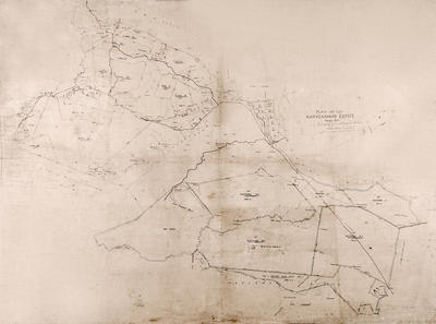
Map, Maraekakaho Estate, Hawke's Bay
Maker
William Ellison & Son
Production date
Dec 1879
Current rights
Public Domain
See full details
Object detail
Brief Description
The map of Maraekakaho Estate, Hawke's Bay which was the property of the Maclean family. Compiled and drawn by W Ellison & Son, December 1879. The Church site shown on the plan is where the plan hung for many years.
Boundaries include the properties of Hugh Campbell, Thomas Mason, H W P Smith, the Carlyle block purchased by D McLean, Hawkeville, Aorangi sections, J G Kinross land; Te Awa o te Atua Block; and Watt & Farmer block.
The plan shows: West Raukawa Block, Ngatarawa Blocks - 1 - 5; Salisbury Plains; part of the Mangaroa Block; Maraekakaho River; Ngaruroro River; Pakihima Stream; Yarrow Creek River; the Wye Stream; Gala Water; Paretua Stream; Wakapiro Bush; Ongaru Swamp; Raupo swamp; the woolshed and church site.
The following Māori sites are noted: Burnt pā; Kopupatuki Pā; Paitutu; Pukeiahua; Nga Mahoriri; Ta Maipupanoko (large stone); Te Popo Hill; Te Aturauha; Te Wakahoro a Pukerau; Po Ketaringa; Te hinwha Moka; Ngapuke ta tua; Puketi; Te Aukupu; Nga Puna a te Aomatahina; Tataa; Ruauku; Mairetukihau.
Maker
Production date
Dec 1879
Production place
Production period
Production technique
Media/Materials description
Linen glued onto hardboard. Hand drawn using black ink and watercolours.
Media/Materials
Measurements
Height x Width: 890 x 1205mm
Classification terms
Subject person
Subject period
Subject date
Dec 1879
Current rights
Public Domain
Credit line
gifted by the Maraekakaho Church Trust Board Incorporated
Other number(s)
m2003/81, 6287, 24766


Public comments
Be the first to comment on this object record.