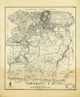
Map, Tahoraiti S.D.
Maker
Department of Lands & Survey
Paul, E V
McMillan, T S
Production date
1940
Current rights
Public Domain
See full details
Object detail
Brief Description
Map, Tahoraiti S.D.
Cadastral map showing boundary lines, survey district boundaries, land blocks, area sizes, rivers and townships in the Woodville Survey District, Norsewood Survey District, Mangatoro Survey District, Wellington Land District. Map includes Tamaki Block, Ututaoroa block, Tiratu block, Dannevirke, Manga-A-Toro, Kaitoki block, Otawhao block. Oringi Waiaruhe blocks, Puketoi and Kumeroa Settlement.
Cadastral map showing boundary lines, survey district boundaries, land blocks, area sizes, rivers and townships in the Woodville Survey District, Norsewood Survey District, Mangatoro Survey District, Wellington Land District. Map includes Tamaki Block, Ututaoroa block, Tiratu block, Dannevirke, Manga-A-Toro, Kaitoki block, Otawhao block. Oringi Waiaruhe blocks, Puketoi and Kumeroa Settlement.
Production date
1940
Production place
Production period
Production technique
Media/Materials description
Printed on cartography paper.
Media/Materials
Measurements
Height x Width: 520 x 432mm
Classification terms
Subject period
Subject date
1940
Current rights
Public Domain
Caption
Collection of Hawke's Bay Museums Trust, Ruawharo Tā-ū-rangi, m2003/46/9
Credit line
gifted by Alexander Turnbull Library
Other number(s)
6195, m2003/46/9, 23962


Public comments
Be the first to comment on this object record.